LightningChartAeronautical Charts & 5 different aviation charts
ArticleReviewing different JS and .NET charting components used for developing aerospace and aviation data apps.
Introduction to aeronautical charts
In this article, we will review a topic a little different than our usual .NET and JS development tutorials. We will review the topic of aeronautical charts, their functions, regulations, and some examples.
For inland traffic, various traffic rules must be taken into account to guarantee the greatest possible safety while traveling from one place to another. In this case, there are also maps and different types of navigation charts that show roads, streets, locations, or geographical spaces to operators.
Having mentioned the above, I think it is quite logical to assume that in airspace some rules and maps help pilots navigate and avoid accidents.
Visual Flight Rules (VFR)
The acronym VFR corresponds to the term Visual Flight Rules, and these are a set of regulations established by aviation authorities that allow pilots to operate an aircraft by observing the terrain. These regulations allow and require the pilot to avoid other aircraft during flight, using visual cues such as landmarks, mountains, and coastlines.
To accredit the minimum VFR requirements, it is necessary to know the flight and equipment conditions. Conditions must be suitable enough to have clear visibility to the ground and other aircraft.
- The cloud ceiling must be kept above one thousand feet above ground level.
- Visibility must be at least three statute miles during the day.
- Visibility must be at least five statute miles at night.
- Temperature inversions must be considered to avoid turbulence.
-
Travel routes must be established based on reported weather conditions.

VFR equipment conditions
1. Altimeter. A measuring instrument that indicates the difference in altitude between the aircraft’s location and a reference point.
2. Anemometer. An instrument that indicates the relative speed of the airplane concerning the air in which it moves, a speed that can be shown in knots (knots), in miles per hour (mph), or both units.
3. Gyrocompass or compass. A mechanical instrument designed to facilitate the use of the magnetic compass.
4. Two-way radio system. To transmit and receive messages with control towers and other aircraft in the vicinity.
Instrument Flight Rules (IFR)
Instrument flight rules are flight regulations used when it is not possible to be guided by visual references during the flight. When these conditions occur, use is made of electronic navigation instruments that generate electronic signals.
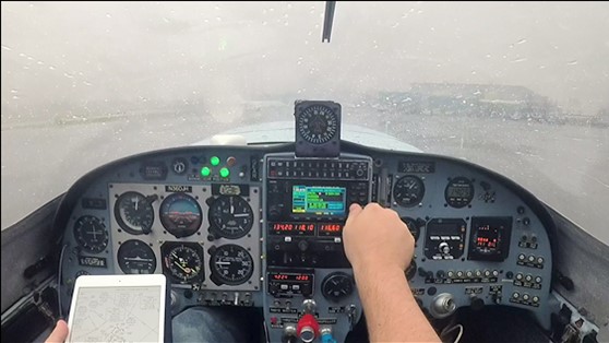
There are two subclasses of IFR regulation:
-
Enroute Low Altitude: Flight rules for altitudes below 18,000 feet.
-
High Altitude Enroute: Flight rules for altitudes above 18,000 feet. This class of IFR is used within the continental US and Alaska.
Aeronautical Charts
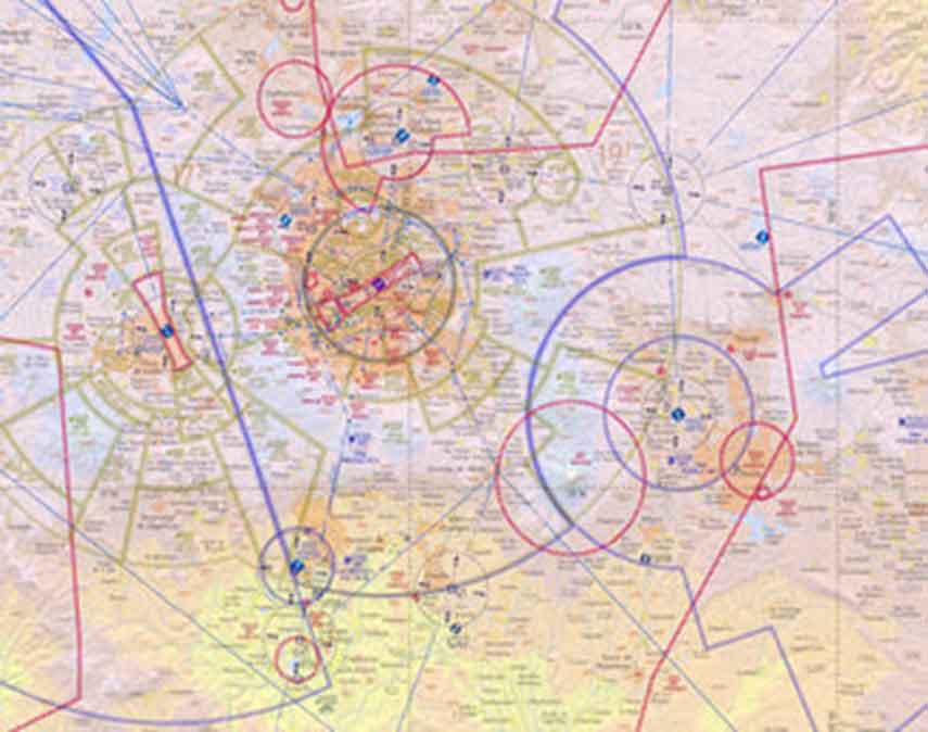
Aeronautical charts are the main navigation tool and help the pilot comply with VFR regulations. What are aeronautical charts used for? Aeronautical charts allow pilots to establish a position, establish a safe altitude, plan a flight route, and know the geographical space over which they will fly.
Currently, it is very common to use satellite maps, such as Google Maps, a tool that indicates traffic, traffic accidents, closed streets, and some weather conditions. Well, the same information can be obtained today with the use of digital tools.
The following image is a common example of cartography that at first glance, looks like a traditional map, but the main difference is the scale. We can observe routes that can cross states, countries, and oceans, and these belong to air transport.
Where can I find aviation charts?
Currently, you can find various platforms that facilitate the development of aerospace applications using aeronautical and aviation charts. For instance, LightningChart .NET and JS charting libraries allow developers to use different components to generate flight route applications based on different operational navigation charts.
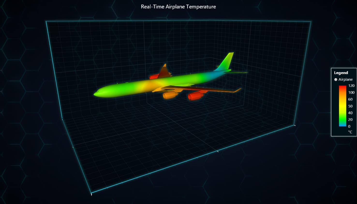
1. Dynamic Coloring of a 3D Mesh Aeroplane
The following model is a 3D representation of an airplane that uses custom coloring to represent different values on an object, in this case, the airplane. This type of aeronautical chart could be useful when, for example, visualizing a specific parameter along the aircraft. The following interactive chart represents temperature data:
2. JavaScript Animated Geographical Temperature Chart
Visualizing temperatures is key in aviation and the following JS aeronautical chart showcases how temperatures vary on a map of the US:
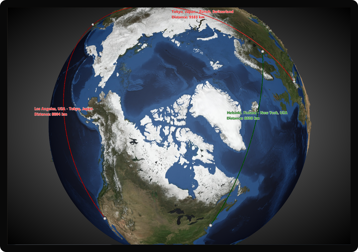
3. Globe Chart
The following aeronautical chart has been developed with LightningChart .NET and is a model of a globe chart mapping commercial flight routes:
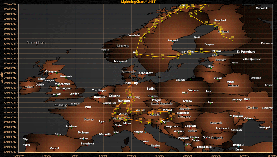
4. Map Routes
This type of map is one of the most commonly used aeronautical charts and helps to visualize different map routes, e.g., air traffic for commercial aviation.
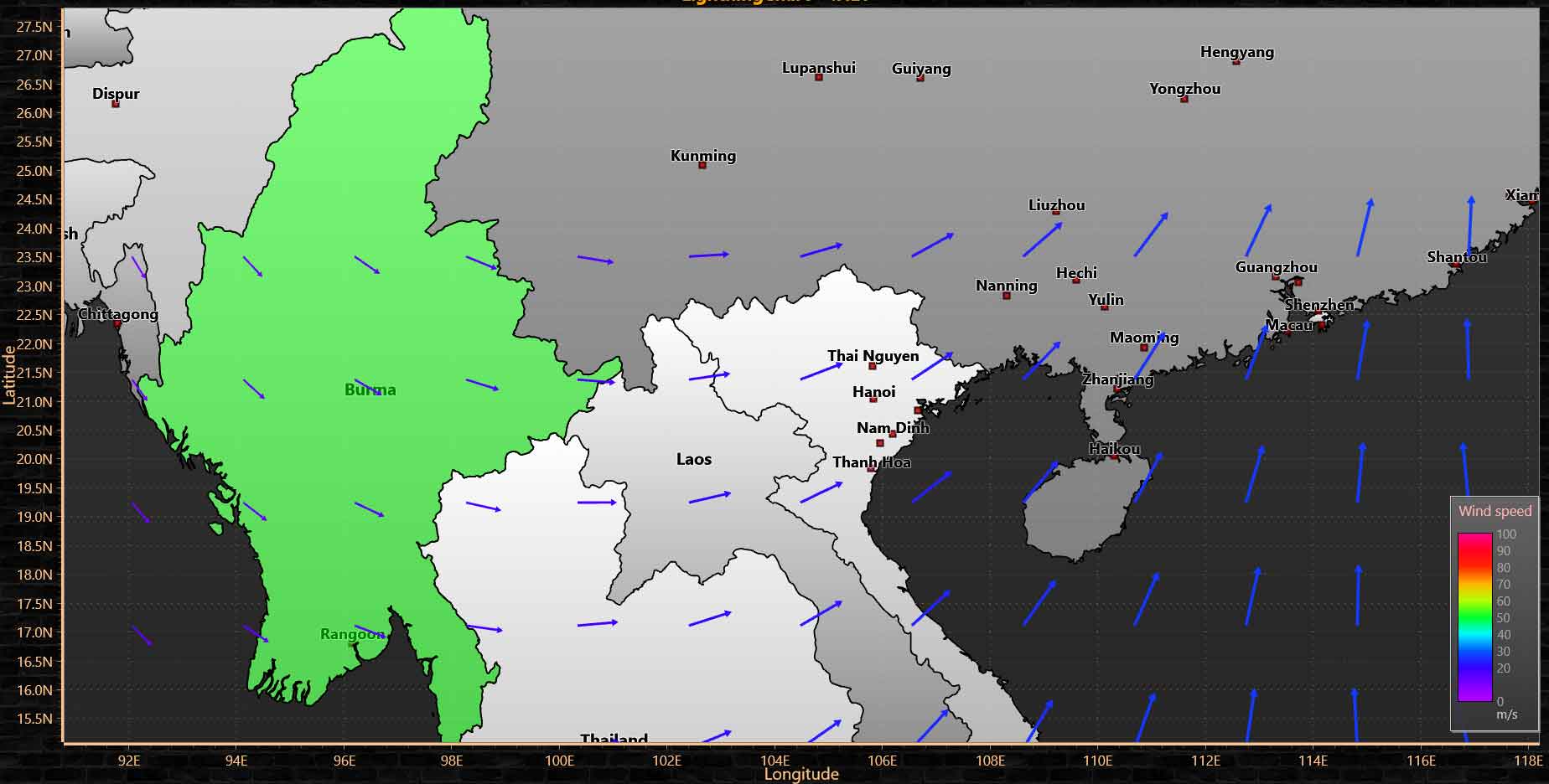
5. Wind Maps
Wind maps are those maps that show wind speed measurements, accurately depending on the location and time indicated. Wind direction is represented with arrows and colors can be used to identify wind speed. In this map, we also use the intensity tool since this way we can represent the change in wind speed by area.
Controlled Airspace Classifications
Controlled classifications are another way to identify flight zones by altitude. This tool helps pilots know the maximum and minimum altitude they should fly at about the flight route.
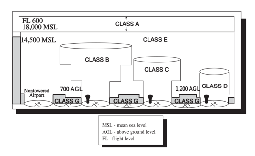
A class
This class is carried out taking into account IFR rules, and its altitude is between 18,000 feet mean sea level (MSL), to flight level 600.
Class B
This class is the most regulated due to the high level of air traffic, and its altitude is around ground level and 10,000 feet MSL.
Class C
Mostly regulated by IFR, class C is within the most common traffic and all aircraft must be constantly in radio communication due to IFR regulations. Its altitude starts from the surface up to 4,000 feet above the airport elevation.
Class D (Delta)
The class is assigned to the airport flight zone and has a maximum altitude of 2500 feet. Being an airport area, it is required to have constant communication between the aircraft and the control tower.
Class E (Eco)
This class covers unclassified areas and its altitude begins at 14,500 feet above sea level. This class is regulated under VFR at high altitudes and IFR on low-altitude routes. VFR visibility requirements:
-
Below 10,000′ MSL: 3 SM visibility, 500′ below, 1,000′ above, 2,000′ horizontal
-
Above 10,000′ MSL: 5 SM visibility, 1,000′ below, 1,000′ above, 1 SM horizontal
G-Class (Golf)
This class corresponds to uncontrolled airspace and therefore is not assigned to the aforementioned classes. Although this space is not regulated, aircraft must meet VFR requirements. Class G airspace will always start at the ground and go up to 14,500′ MSL as a maximum.
Conclusion
Well, we have reached the end of this aeronautical charts article. We briefly looked at some concepts that help us understand how aircraft must transit through airspace.
VFR (Visual Flight Rules) are a set of regulations that must be taken into account to carry out flights observing the terrain. VFR is used at high altitudes as long as visibility is safe and reliable. IFR (Instrument Flight Rule), is the set of regulations on which to fly when the pilot’s visual conditions are not safe for flight. They are also used at low altitudes and takeoff areas with a lot of air traffic.
The IFR regulation requires the use of instruments that help the pilot determine a safe flight plan. Among the most used tools are aeronautical charts, aerospace maps, and controlled classifications. These tools allow you to create a flight plan and route.
This flight plan should help the pilot identify controlled areas and their classifications which will help the pilot know the maximum and minimum altitude at which to travel.
There are more flight rules by classification, and together they will help the pilot to have a safe and risk-free flight. I hope you enjoyed this article, thanks, and goodbye!


